HUNDREDS of homes will be evacuated today as Britain's worst-ever run of storms continues with 80mph gales, 'danger to life' floods and the possibility of TWO TORNADOES.
It's the first time on record that three named tempests have happened within just days of each other – with unusually ferocious Storm Eunice killing four and plunging 1.3million homes into darkness.


Storm Franklin, an 800-mile wide squall, will bring "severe and damaging gusts" across Northern Ireland from tonight until tomorrow morning.
An amber warning is in place from midnight.
And Met Office forecaster Marco Petagna shared a warning from the Tornado and Storm Research Organisation on Twitter, telling followers: "Although a very low risk, a tornado or two is possible associated with today's squally cold front."
Two inches of snow will fall in some northern postcodes, while in Manchester, locals are being forced from their homes amid fears the River Mersey will flood at East and West Didsbury.
Manchester City Council confirmed 460 households are being told to leave urgently.
Meanwhile, more than 83,000 people around the UK are still without power after the worst winter tempest in a generation.
The Met Office has issued a slew of weather warnings for today and tomorrow, with millions facing misery from high winds as they travel to work on Monday.
Forecasters say blasts will cause even more power cuts, transport delays and damage.
It comes as:
- Die-hard party-goers made the most of their Saturday night, despite the terrible weather
- More than 40,000 households are still without power after killer Storm Eunice
- A mum told of how she cowered inside while gale-force winds tore off her roof
- Tributes have been paid to a 23-year-old dad killed during the worst tempest in a generation
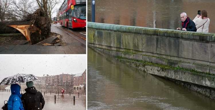
- Footage shows the terrifying moment a tree hit a bus on Friday
Sunday's yellow warnings cover Wales and most of England from midday until 3pm, and the North West and Northern Ireland from midday until midnight.
Identical wind warnings have been issued for Monday.
A yellow warning for rain, meaning "there is a chance that homes and businesses could be flooded", is also in place for Cumbria, Lancashire and West Yorkshire from midnight until 6pm on Sunday.
More than 3.1ins will fall in the worst-hit areas.
The run of terrible weather began with Storm Dudley on Wednesday.
Meteorologist Becky Mitchell said three named storms in such quick succession is a first since the system was introduced seven years ago.
"It's the first time we've had three named storms within a week, and we started the storm-naming system in 2015," she said.
? Read our weather forecast live blog for the latest updates
"We've got a really active jet stream, which is why we're seeing so many storms track right towards the UK.
"We had Dudley on Wednesday, Eunice on Friday and Franklin today."
Her colleague Craig Snell told Sun Online conditions will finally ease next week.
"It'll be blustery as we go through the week, but everything looks a little bit more typical for this time of year," he said.
"It'll be windy, but at the moment, there aren't any warnings past Monday, and we're certainly not looking at naming more storms in the days to come.
"After we get rid of Franklin, it'll still be windy, but hopefully not on the same scale as the past few days.
KILLER STORM
"It's certainly been very, very unsettled recently.
"This has been a very notable spread of weather."
He said the strongest winds will lash the country tomorrow morning.
"The most likely place for disruption is Northern Ireland, but there could also be impacts along the Lancashire and Merseyside coast, and maybe up into North Wales," he said.
"During the small hours, winds could reach 80mph along the north coast of Northern Ireland, while any coastline attached to the Irish Sea could easily see gusts of 60 to 70mph."
Friday saw the worst storm in years with Eunice, which brought down trees, tore roofs from houses and toppled power lines.
The Energy Networks Association said it believes the UK may have experienced a record outage over a 24-hour period during the tempest, with around 1.3million homes affected.
Ross Easton of the organisation said 8,000 engineers are working to reconnect customers in a huge national effort, but many homes will still be without power next week.
MORE TO COME
At the height of the storm, the roof of the O2 Arena in London was damaged – causing rapper Dave's upcoming concerts to be postponed – and the spire of St Thomas Church in Wells, Somerset, crashed to the ground.
The O2 said today that it expected the scheduled UB40 gig to go ahead as planned on Friday. The venue will remain closed until then while repairs are carried out.
The Association of British Insurers indicated that the clean-up across the UK could cost more than £300m.
A spokesman said: "No two storms are the same.
"The last significant storms to hit the UK – Ciara and Dennis – led to insurers paying out over £360m."
National Rail has warned there is still "major disruption" to train services "across most of Great Britain".
Tragically, three Brits and an Irishman are known to have been killed on Friday.
Most read in News
ANOTHER BLOW 
Franklin named as third storm in a WEEK as 80mph gales & 2ins of rain blast UK

Boris to announce end of isolation rules TOMORROW in victory against Covid

Brit mum who fled UK to join fugitive husband found stabbed to death

Putin 'set to drop 44 ton Father Of All Bombs' in Ukraine blitz
However, there was little respite even after winds eased as new alerts came into force for 80mph gales today.
Forecaster Aidan McGivern said: "The winds pick up significantly later in the day on Sunday.
"There's the risk for northern parts of the country – northern England, Scotland, Northern Ireland – of 50 to 60mph gusts inland and 70 to 80mph around exposed coasts and hills."


Source: Read Full Article