Ian Collins clashes with XR member over China's role in climate change
We use your sign-up to provide content in ways you’ve consented to and to improve our understanding of you. This may include adverts from us and 3rd parties based on our understanding. You can unsubscribe at any time. More info
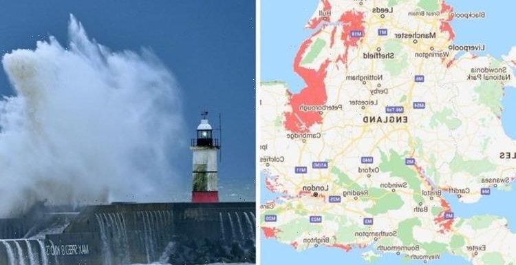
The latest Sea Projection maps show that huge swathes of UK’s coastline could be underwater permanently due to climate change in less than 90 years time. If the projections are accurate, vital roads, services and holiday destinations will be impacted.
Naturally the most susceptible to the effects of climate change are coastal and low-lying areas, as well as those on major rivers and waterways.
According to the map, the east of England looks to be the worst affected area.
The map predicts that by 2100, Skegness, King’s Lynn, Great Yarmouth, Boston and Peterborough could all be underwater.
Further north, parts of Doncaster and Lincoln could be facing the most serious repercussions, whereas Grimsby, Hull and Barton-upon-Humber could all be unrecognisable.


On the other side of the map, huge areas of Cardiff and Swansea in Wales would be left underwater.
Even parts of the capital are at risk, particularly those closest to the River Thames.
Since 1993, sea level growth has been accelerating to an average of 0.12 to 0.14 inches a year, roughly twice as fast as the long-term trend.
The modelling from Climate Central is based on the projection that his rapid growth in the rate of sea-level rises will continue.

According to the organisation, coastal areas are expected to regularly fall below sea level over the next 30 years.
In 2019, a study projected that sea levels will rise between 30cm and 34 cm by 2050.
However so far, sea level rises have been much smaller – but this doesn’t mean places aren’t at risk.
DON’T MISS
Scientists baffled by people who ‘turn streetlights off’ by walking by [REPORT]
Alpaca Geronimo getting saved for science? Vets hope so [INSIGHT]
Jeremy Vine panel erupts as Carole Malone clashes with XR protestor [REPORT]
Why are sea levels rising?
Sea levels began rising throughout the 20th century, almost all of which can be attributed to human activity’s devastating effect on the climate.
Hotter temperatures are created by greenhouse gas emissions, which are caused by burning fossil fuels – coal, gas, and oil.
This causes the climate to get warmer, which in turn leads to the expansion of water volume and melting of polar ice, glaciers and sheets.

Environmental catastrophe is on the doorstep of billions across the world, as highlighted by the damning IPCC report earlier this year.
The report warned that extreme heat, droughts, flooding, and rising sea levels will all be problems within the coming years if humanity doesn’t act immediately.
Dr Scott Kulp, a senior scientist at Climate Central and lead author of the study, said: “These assessments show the potential of climate change to reshape cities, economies, coastlines, and entire global regions within our lifetimes.
“As the tideline rises higher than the ground people call home, nations will increasingly confront questions about whether, how much, and how long coastal defences can protect them.”
Source: Read Full Article